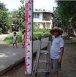
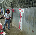
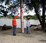
Both FM’s are in Barangay Sapang Bayan. FM1 is painted on a wooden electric post about 3 meters in front of the house of Patricia del Rosario. Similarly, FM2 is also painted on a wooden electric post some 3 meters in front of the house of Isagani Sunga (see sketch above).
| Marker Name | : Sapang Bayan FM’s 1 and 2 |
| Location | : Barangay Sapang Bayan |
| Latitude | : 14 º 55’ 15.6” N |
| Longitude | : 120 º 46’ 04.2” E |
| Elevation | : 7.6 meters (estimated) |
| Barangay Gatbuca |
The flood marker is painted on a concrete wall along a small walkway protected by a concrete riprap adjacent to the river. The FM is some 8 meters from the house of Yoli Bagimbing located at the right bank, upstream portion of the Calumpit Bridge.
| Marker Name | : Gatbuca |
| Location | : Barangay Gatbuca |
| Latitude | : 14 º 55’ 18.7” N |
| Longitude | : 120 º 45’ 52.1” E |
| Elevation | : 7.9 meters (estimated) |
| Barangay San Miguel |
Flood marker is painted on a wooden electric post fronting a street, and situated some 8 meters south of the house of Rosalina Lubao. The post is located on the right bank of the Pampanga River about 4 meters from the right water edge.
| Marker Name | : San Miguel |
| Location | : Barangay San Miguel |
| Latitude | : 14 º 55’ 02.3” N |
| Longitude | : 120 º 44’ 32.6” E |
| Elevation | : 5.8 meters (estimated) |
| Barangay Frances |
The flood marker is painted on a concrete post along a barangay road, situated in the front yard of the house of Victorio Benlot or some 50 meters from the right water edge of the Pampanga River. The FM is around 15 meters west of the Gospel Christian Church.
| Marker Name | : Frances |
| Location | : Barangay Frances |
| Latitude | : 14 º 55’ 15.3” N |
| Longitude | : 120 º 45’ 39.2” E |
| Elevation | : 7.6 meters (estimated) |
| Barangay Iba O’Este |
The flood marker is painted on a concrete wall adjacent to the Labangan River and the tricycle terminal on the right bank of the said river or some 15 meters downstream of the Labangan-1 Bridge
| Marker Name | : Iba O’Este |
| Location | : Barangay Iba-O-Este |
| Latitude | : 14 º 54’ 11.2” N |
| Longitude | : 120 º 46’ 11.4” E |
| Elevation | : 7.0 meters (estimated) |
| Barangay Calizon |
The flood marker is painted on the 4th concrete post from the dike road coming from Barangay Balungao, Calumpit. It is along the municipal road connecting Barangay Balungao and Barangay Bulusan, all in the town of Calumpit.
| Marker Name | : Calizon |
| Location | : Barangay Calizon |
| Latitude | : 14 º 54’ 54.5” N |
| Longitude | : 120 º 45’ 24.9” E |
| Elevation | : 9.4 meters (estimated) |
| Barangay San Jose, Purok 2 |
The flood marker is painted on a concrete post with markings of “TLN-64394”, situated along the municipal road called “Kalsadang Putol” connecting Barangay San Juan, Hagonoy with Barangay Sta. Lucia, Calumpit. It is fronting the house #151 and some 2 meters on the left of house #246.
| Marker Name | : San Jose, Purok 2 |
| Location | : Purok 2, Brgy. San Jose |
| Latitude | : 14 º 53’ 11.9” N |
| Longitude | : 120 º 43’ 46.7” E |
| Elevation | : 5.2 meters (estimated) |


