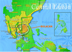
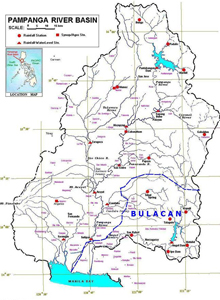
The province of Bulacan forms part of the economic area of Region 3 situated in the Island of Luzon (See Figure 1.0 below). A big portion of the province is covered by the basin of the Pampanga River (See Figure 2.0 below).
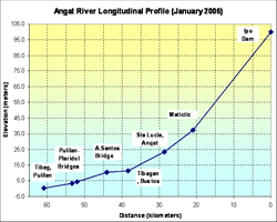
Within the province are three dams, Angat, Ipo and Bustos dams. Angat dam, a hydroelectric dam, is the biggest of the three and drains an aggregate area of 568 km2. The Ipo dam is primarily a diversion dam and diverts water from the Angat and Ipo Rivers into tunnels that lead to La Mesa reservoir and Balara filtration areas. Ipo Dam is minimally an impounding reservoir with a capacity of only around 7.5M m3 compared to Angat dam which has a reservoir capacity of around 850M m3. If the impounded water exceeds this volume, water starts to overflow the radial gates. Ipo Dam is around 7 km. downstream of the Angat Dam. On the other hand, Bustos Dam is an irrigation dam that further impounds and diverts the Angat River and is situated a few kilometers downstream of Angat and Ipo Dams, respectively. Angat River runs for about 61 kilometers from the Ipo reservoir to it’s diversion in Labangan channel (See Figure 3.0 below).
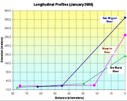
Some of the active rivers and tributaries in the Province are the San Miguel and Maasim Rivers, both tributaries to the Pampanga River via the Candaba swamp; the Sta. Maria River which forms a separate small watershed outside the Pampanga River basin. Most of the rivers within the province have headwaters originating from the Sierra Madre mountain range (See Figure 4.0 below).
The province of Bulacan has sufficient water resource to supply its domestic as well as its agricultural needs. Unfortunately, though, there are times when excess of water from the hinterlands on the east and from other river resource north of the province simultaneously comes down and inundates vast areas of the province during times of inclement weather condition.